Repeat of Extremely Cold Winter, NOT likely
National Oceanic and Atmospheric Administration:
Another warm winter likely for western U.S., South may see colder weather
What does this mean?
A repeat of last year’s extremely cold, snowy winter east of the Rockies is unlikely. We can hope, and repeat, HOPE, for less congestion than last year’s wintry mess in Chicago and New York. Unfortunately, The Precipitation Outlook favors above-average precipitation across the southern tier.
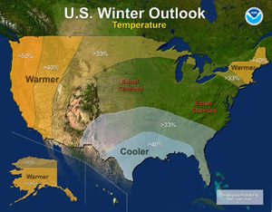
Last year’s winter was exceptionally cold and snowy across most of the United States, east of the Rockies. A repeat of this extreme pattern is unlikely this year, although the Outlook does favor below-average temperatures in the south-central and southeastern states.
In addition, the Temperature Outlook favors warmer-than-average temperatures in the Western U.S., extending from the west coast through most of the inter-mountain west and across the U.S.-Canadian border through New York and New England.
The rest of the country falls into the “equal chance” category, meaning that there is not a strong enough climate signal for these areas to make a prediction, so they have an equal chance for above-, near-, or below-normal temperatures and/or precipitation.
This seasonal outlook does not project where and when snowstorms may hit or provide total seasonal snowfall accumulations. Snow forecasts are dependent upon the strength and track of winter storms, which are generally not predictable more than a week in advance.
What does this mean?
We can’t predict how you should route your freight or if a delay will occur! We can continue to hope though!